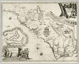
A new discription of Carolina by the order of the Lords Proprietors
This map, by John Ogilby, was created around 1671. It shows eastern North Carolina and Virginia and the Sappony Indian tribe in the area. To view the map and zoom in on specific areas visit the UNC Libraries North Carolina Collection.

All Rights Reserved
"All rights reserved" is a traditional copyright term that indicates that the copyright holder reserves for his/her/their own use all of the rights given to copyright owners under U.S. copyright law. Items that are included in NCpedia and/or ANCHOR with this rights statement appear by agreement or permission from the rights holder or the institution that holds the item. Click "Available at" to visit the website for the collection where the item appears for more information about the rights or specific uses allowed. For all other non-specified uses, please contact the copyright holder or item owner.
Add a comment
PLEASE NOTE: NCpedia provides the comments feature as a way for viewers to engage with the resources. Comments are not published until reviewed by NCpedia editors at the State Library of NC, and the editors reserve the right to not publish any comment submitted that is considered inappropriate for this resource. NCpedia will not publish personal contact information in comments, questions, or responses. If you would like a reply by email, note that some email servers, such as public school accounts, are blocked from accepting messages from outside email servers or domains. If you prefer not to leave an email address, check back at your NCpedia comment for a reply. Please allow one business day for replies from NCpedia. Complete guidelines are available at https://ncpedia.org/about.